

Franklin County Engineer Facebook Feed

Franklin County Engineer

As a local public works agency headquartered in Columbus, Ohio, the Franklin County Engineer's Office is responsible for the maintenance and construction of 271 miles of county roadway and 351 county bridges, as well as upkeep of all county ditches, drains, retention basins, and other storm water facilities within the right-of-way of county roads in unincorporated areas. To meet the continuing development and infrastructure needs of Franklin County, the Engineer's Office utilizes the latest technologies for determining and maintaining roadway centerlines and boundaries; retracing and setting new monuments for original public land surveys; preparing geographic information system mapping for real estate tax assessments; and establishing precise countywide horizontal and vertical control to maintain uniformity in construction, surveying, and mapping.
Franklin County Engineer
Beach Road, between Amity Road and Plain City-Georgesville Road, will be closed beginning Monday, August 31, 2026, for bridge rehabilitation work. The closure will last approximately five (5) days, weather permitting.
Franklin County Engineer
Cooke Road improvements are moving forward! Crews are making progress on storm sewer, roadway construction and new curb and gutter from Karl Road to Cleveland Avenue. Beginning Sept. 14, one westbound lane will reopen between Karl Road and Dresden Street, weather permitting.
Franklin County Engineer
Notice to Contractors: We are accepting bids on the Kropp Road Drainage Outlet Improvement Part 2 Improvements Project. Visit: https://www.bidexpress.com/solicitations for more information.
Franklin County Engineer
Cooke Road, between Dresden Street and Walford Street, is closed for roadway improvements and the addition of pedestrian facilities. The closure will last approximately seventy-five (75) days, weather permitting.
Franklin County Engineer
We had a fantastic time at New Albany’s Touch-A-Truck event! Families stopped by to explore our snowplow truck, get a closer look at the equipment we use to keep our roadways safe, and pick up some fun giveaways. The day was filled with lots of excitement, curious kids, and wonderful conversations with the community. Thank you to the New Albany, Ohio Government for hosting such a fun and engaging event!
Franklin County Engineer
Hardy Parkway Street, south of Frank Road, is now closed for roadway improvements. The road is expected to remain closed for approximately 30 days, weather permitting.
Franklin County Engineer's Office
970 DUBLIN ROAD
COLUMBUS, OHIO 43215
(614) 525-3030
fracoeng@franklincountyengineer.org

Follow Us

Top
 

Maps

Maps

Road Map – 2025 Edition – NOW AVAILABLE

For those wishing to pick up a road map on the run, there is a distribution box located in our front parking lot at 970 Dublin Road that is accessible from your vehicle 24 hours a day.

View Online

The Franklin County Folded Road Map can be obtained, free of charge, at all of the Franklin County Engineer’s Offices:

Main Office

970 Dublin Road

(614) 525-3030

Tax Map Office

373 South High Street, 19th Floor

(614) 525-3084

West Maintenance Facility

4444 Fisher Road

(614) 525-6780

East Maintenance Facility

4801 Hendron Road

(614) 525-6803

A complementary print-version of the Franklin County Atlas can be given from our headquarters lobby at 970 Dublin Road, and the Tax Map Office at 373 South High Street, on the 19th floor, free of charge. They are a useful guide for traveling around the county.

Learn more

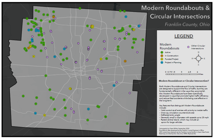
Modern Roundabouts of Franklin County

Screenshot 2025-06-26 073203

The Franklin County Road Map can be obtained, free of charge, through the Engineer’s Offices and at various county, municipal, township, and state facilities. Our Surveying Department has gathered information from numerous public entities such as the Franklin County Auditor’s Office, Metro Parks, Ohio Department of Transportation, and City of Columbus to create the most accurate and comprehensive road map. About 1,250 changes were made to our land and highway record data base since the publication of the 2009 edition.

The five-color 44-inch wide and 37-inch tall road map shows over 12,000 public roads, which are listed in the street locator index, and the locations of 1,000 points of interest such as airports, fire departments, government buildings, high schools, hospitals, police departments, post offices, shopping centers, and universities. Also shown are regional street address numbers that are useful in locating specific addresses.

For more information about the road map, or to suggest revisions, please contact Ben McCown, GIS Manager.

Historical Maps and Information

Historical maps of Franklin County dating back to 1842, as well as township maps, road record books, subdivision plats, private surveys, county road construction plans, and county road right-of-way plans are housed in the Records Management Office of the Surveying Department. Copies of these records and others are available to the public free of charge or for a nominal fee. Most can be obtained in both hardcopy or digital formats.

For more information, please contact Glenn Thompson, Records Analyst at (614) 525-3045.